
Sint-Maria-Oudenhove topographic map
Interactive map
Click on the map to display elevation.
About this map
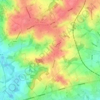
Name: Sint-Maria-Oudenhove topographic map, elevation, terrain.
Average elevation: 67 m
Minimum elevation: 28 m
Maximum elevation: 101 m
Other topographic maps
Click on a map to view its topography, its elevation and its terrain.
Grotenberge
België > Vlaanderen > Zottegem
Grotenberge, Zottegem, Aalst, Oost-Vlaanderen, Vlaanderen, België
Average elevation: 70 m