
Courbaton topographic map
Interactive map
Click on the map to display elevation.
About this map
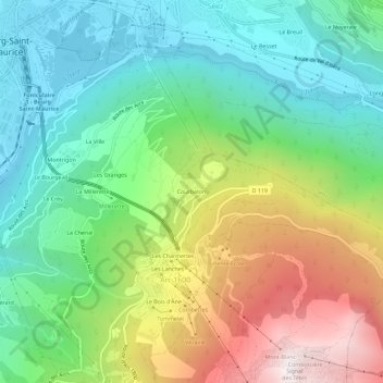
Name: Courbaton topographic map, elevation, terrain.
Average elevation: 1,345 m
Minimum elevation: 796 m
Maximum elevation: 2,374 m
Other topographic maps
Click on a map to view its topography, its elevation and its terrain.
Les Charmettes
France > Auvergne-Rhône-Alpes > Savoie > Bourg-Saint-Maurice > Arc 1600
Les Charmettes, Arc 1600, Bourg-Saint-Maurice, Albertville, Savoie, Auvergne-Rhône-Alpes, France métropolitaine, 73700, France
Average elevation: 1,489 m