
Tlacuiloltécatl Chico (Nogales) topographic map
Interactive map
Click on the map to display elevation.
About this map
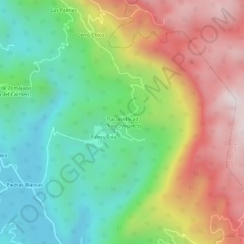
Name: Tlacuiloltécatl Chico (Nogales) topographic map, elevation, terrain.
Location: Tlacuiloltécatl Chico (Nogales), Zongolica, Veracruz, México (18.65191 -96.90613 18.69191 -96.86613)
Average elevation: 860 m
Minimum elevation: 468 m
Maximum elevation: 1,413 m
Other topographic maps
Click on a map to view its topography, its elevation and its terrain.
Real del Monte
México > Veracruz > Zongolica > Real del Monte
Real del Monte, Zongolica, Veracruz, México
Average elevation: 1,121 m