
Cairo topographic map
Interactive map
Click on the map to display elevation.
About this map
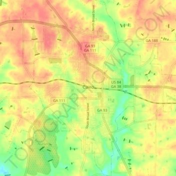
Name: Cairo topographic map, elevation, terrain.
Location: Cairo, Grady County, Georgia, United States (30.84130 -84.24206 30.91238 -84.16482)
Average elevation: 76 m
Minimum elevation: 41 m
Maximum elevation: 100 m
Other topographic maps
Click on a map to view its topography, its elevation and its terrain.
Whigham
United States > Georgia > Grady County
Whigham, Grady County, Georgia, United States
Average elevation: 85 m
Pine Park
United States > Georgia > Grady County
Pine Park, Grady County, Georgia, United States
Average elevation: 62 m