
Bridgefoot topographic map
Interactive map
Click on the map to display elevation.
About this map
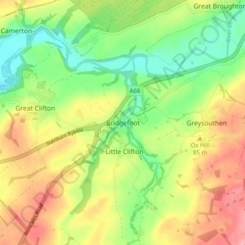
Name: Bridgefoot topographic map, elevation, terrain.
Average elevation: 65 m
Minimum elevation: 14 m
Maximum elevation: 123 m
Other topographic maps
Click on a map to view its topography, its elevation and its terrain.
Winder Gate
United Kingdom > England > Cumberland > Frizington
Winder Gate, Arlecdon and Frizington, Frizington, Cumberland, England, CA26 3QS, United Kingdom
Average elevation: 139 m
Carlisle
United Kingdom > England > Cumberland
Carlisle, Cumberland, England, United Kingdom
Average elevation: 31 m
Legburthwaite
United Kingdom > England > Cumberland
Legburthwaite, Cumberland, England, CA12 4TQ, United Kingdom
Average elevation: 392 m
Braithwaite
United Kingdom > England > Cumberland
Braithwaite, Cumberland, England, CA12 5TJ, United Kingdom
Average elevation: 176 m
The Green
United Kingdom > England > Cumberland
The Green, Cumberland, England, LA18 5HL, United Kingdom
Average elevation: 64 m
Emerald Pools
United Kingdom > England > Cumberland
Emerald Pools, Wasdale, Cumberland, England, United Kingdom
Average elevation: 523 m
Drumburgh
United Kingdom > England > Cumberland
Drumburgh, Cumberland, England, CA7 5DP, United Kingdom
Average elevation: 6 m
Penrith
United Kingdom > England > Cumberland
Penrith, Cumberland, England, United Kingdom
Average elevation: 162 m
Rottington
United Kingdom > England > Cumberland
Rottington, Cumberland, England, CA28 9UR, United Kingdom
Average elevation: 56 m