
Malekhu topographic map
Interactive map
Click on the map to display elevation.
About this map
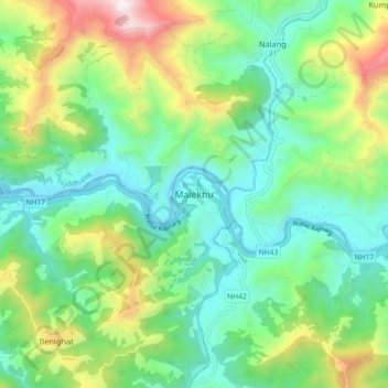
Name: Malekhu topographic map, elevation, terrain.
Location: Malekhu, Benighat Rorang, Dhading, Bagmati Province, Nepal (27.77371 84.78724 27.85371 84.86724)
Average elevation: 681 m
Minimum elevation: 323 m
Maximum elevation: 1,517 m
Other topographic maps
Click on a map to view its topography, its elevation and its terrain.
Semjong
Nepal > Bagmati Province > Dhading
Semjong, Netrawati, Dhading, Bagmati Province, Nepal
Average elevation: 1,534 m
Salanghat
Nepal > Bagmati Province > Dhading > Malekhu
Salanghat, Benighat Rorang-03, Malekhu, Benighat Rorang, Dhading, Bagmati Province, Nepal
Average elevation: 617 m