
Make a donation
Bahawalnagar topographic map
Click on the map to display elevation.
Make a donation
Bahawalnagar
In 1904 when Nawab Mohammad Bahawal Khan Abbasi IV, who originally ruled over Bahawalpur State visited Rojhanwali the people asked that with His permission they want to rename the city on the name of Nawab, The Nawab allowed them with pleasure and since then the city is named as Bahawalnagar. With the advent of railways, 40–50 shops with a population of 100 dwelling units developed at existing railway bazar. Though this site was not fit for flourishing as the topographical features were not favorable and drinking water was unfit for health. With the introduction of canal system, it has become fertile area. The real achievement was Fordwah Canal which brought almost the entire district under the command of irrigation system. The town developed as colony town south of railway station.
Make a donation
About this map
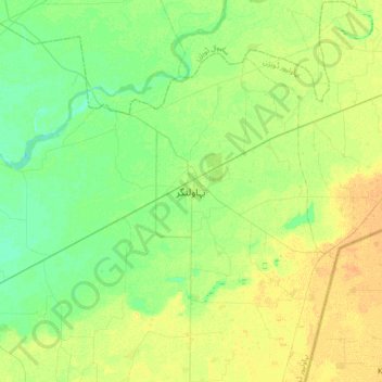
Name: Bahawalnagar topographic map, elevation, terrain.
Average elevation: 158 m
Minimum elevation: 148 m
Maximum elevation: 170 m
Make a donation
Other topographic maps
Click on a map to view its topography, its elevation and its terrain.