
Kanichar topographic map
Interactive map
Click on the map to display elevation.
About this map
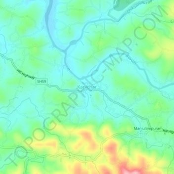
Name: Kanichar topographic map, elevation, terrain.
Location: Kanichar, Iritty, Kannur District, Kerala, 670674, India (11.88596 75.76587 11.92596 75.80587)
Average elevation: 105 m
Minimum elevation: 58 m
Maximum elevation: 234 m
Other topographic maps
Click on a map to view its topography, its elevation and its terrain.
Chavassery
Chavassery, Iritty, Kannur District, Kerala, 670702, India
Average elevation: 71 m
Kakkayangad
Kakkayangad, Iritty, Kannur District, Kerala, 670673, India
Average elevation: 94 m
Kelakam
India > Kerala > Iritty > Adakkathodu
Kelakam, Adakkathodu, Iritty, Kannur district, Kerala, 670651, India
Average elevation: 324 m