
Sippenaeken topographic map
Interactive map
Click on the map to display elevation.
About this map
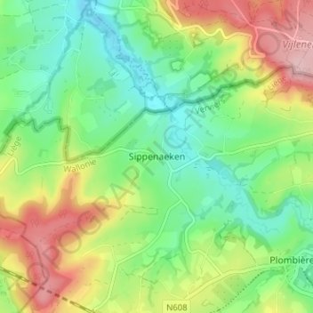
Name: Sippenaeken topographic map, elevation, terrain.
Location: Sippenaeken, Luik, Wallonië, 4851, België (50.73097 5.91325 50.77097 5.95325)
Average elevation: 182 m
Minimum elevation: 115 m
Maximum elevation: 289 m
De hoogte van de dorpskern van Sippenaeken bedraagt ongeveer 155 meter.