
Luang Prabang topographic map
Interactive map
Click on the map to display elevation.
About this map
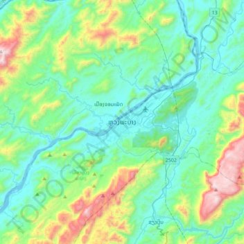
Name: Luang Prabang topographic map, elevation, terrain.
Average elevation: 557 m
Minimum elevation: 267 m
Maximum elevation: 1,594 m
Das historische Zentrum der Stadt liegt im Schutz der Spornlage zwischen Mekong und seinem Nebenfluss Nam Khan auf rund 300 Meter Höhe. Sie ist ein Handelszentrum für Reis, Kautschuk und Teakholz. Außerdem werden handwerkliche Produkte wie Holzarbeiten, Textilien und Papier hergestellt. Luang Prabang ist Sitz einer Universität, der Souphanouvong-Universität.