
Sinai Peninsula topographic map
Interactive map
Click on the map to display elevation.
Sinai Peninsula
Sinai is one of the coldest provinces in Egypt because of its high altitudes and mountainous topographies. Winter temperatures in some of Sinai's cities and towns reach −16 °C (3 °F).
About this map
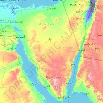
Name: Sinai Peninsula topographic map, elevation, terrain.
Location: Sinai Peninsula, Egypt (27.72414 32.31018 31.32347 34.90369)
Average elevation: 457 m
Minimum elevation: -415 m
Maximum elevation: 2,521 m
Other topographic maps
Click on a map to view its topography, its elevation and its terrain.