
Bowers topographic map
Interactive map
Click on the map to display elevation.
About this map
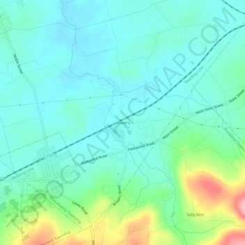
Name: Bowers topographic map, elevation, terrain.
Average elevation: 158 m
Minimum elevation: 123 m
Maximum elevation: 273 m
Other topographic maps
Click on a map to view its topography, its elevation and its terrain.
Eagle Point
United States > Pennsylvania > Berks County > Maxatawny Township
Eagle Point, Maxatawny Township, Berks County, Pennsylvania, 19530, United States
Average elevation: 167 m
Hinterleiter
United States > Pennsylvania > Berks County > Maxatawny Township
Hinterleiter, Maxatawny Township, Berks County, Pennsylvania, 19511, United States
Average elevation: 141 m
Maxatawny
United States > Pennsylvania > Berks County > Maxatawny Township
Maxatawny, Maxatawny Township, Berks County, Pennsylvania, 19538, United States
Average elevation: 156 m
Monterey
United States > Pennsylvania > Berks County > Maxatawny Township
Monterey, Maxatawny Township, Berks County, Pennsylvania, 19538, United States
Average elevation: 158 m