
Bergeron topographic map
Interactive map
Click on the map to display elevation.
About this map
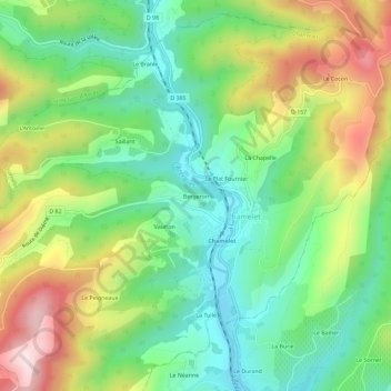
Name: Bergeron topographic map, elevation, terrain.
Average elevation: 459 m
Minimum elevation: 291 m
Maximum elevation: 736 m
Other topographic maps
Click on a map to view its topography, its elevation and its terrain.
Le Cocon
France > Auvergne-Rhône-Alpes > Rhône > Chamelet
Le Cocon, Chamelet, Villefranche-sur-Saône, Rhône, Auvergne-Rhône-Alpes, France métropolitaine, 69620, France
Average elevation: 525 m
Le Plat Fournier
France > Auvergne-Rhône-Alpes > Rhône > Chamelet
Le Plat Fournier, Chamelet, Villefranche-sur-Saône, Rhône, Auvergne-Rhône-Alpes, France métropolitaine, 69620, France
Average elevation: 458 m