
São Bento topographic map
Interactive map
Click on the map to display elevation.
About this map
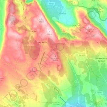
Name: São Bento topographic map, elevation, terrain.
Location: São Bento, Porto de Mós, Leiria, 2480-142, Portugal (39.47570 -8.81741 39.55985 -8.72893)
Average elevation: 418 m
Minimum elevation: 227 m
Maximum elevation: 588 m
Other topographic maps
Click on a map to view its topography, its elevation and its terrain.
Raimunda
Portugal > Leiria > Porto de Mós
Raimunda, São Bento, Porto de Mós, Leiria, 2485, Portugal
Average elevation: 364 m
Fontainhas
Portugal > Leiria > Porto de Mós
Fontainhas, São Bento, Porto de Mós, Leiria, 2480-142, Portugal
Average elevation: 375 m