
Badger Lake Dam topographic map
Interactive map
Click on the map to display elevation.
About this map
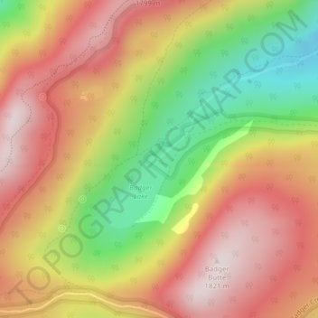
Name: Badger Lake Dam topographic map, elevation, terrain.
Location: Badger Lake Dam, Hood River County, Oregon, United States (45.30286 -121.55958 45.30296 -121.55948)
Average elevation: 1,565 m
Minimum elevation: 1,252 m
Maximum elevation: 1,808 m
Other topographic maps
Click on a map to view its topography, its elevation and its terrain.
Hood River
United States > Oregon > Hood River County
Hood River, Hood River County, Oregon, United States
Average elevation: 112 m
Parkdale
United States > Oregon > Hood River County > Parkdale
Parkdale, Hood River County, Oregon, United States
Average elevation: 538 m
Odell
United States > Oregon > Hood River County
Odell, Hood River County, Oregon, United States
Average elevation: 244 m
Government Cove
United States > Oregon > Hood River County > Cascade Locks
Government Cove, Cascade Locks, Hood River County, Oregon, United States
Average elevation: 89 m
Mount Hood
United States > Oregon > Hood River County
Mount Hood, Hood River County, Oregon, United States
Average elevation: 2,716 m
Cascade Locks Marine Park
United States > Oregon > Hood River County > Cascade Locks
Cascade Locks Marine Park, Cascade Locks, Hood River County, Oregon, United States
Average elevation: 72 m
Dee
United States > Oregon > Hood River County
Dee, Hood River County, Oregon, United States
Average elevation: 424 m
Columbia River
United States > Oregon > Hood River County > Cascade Locks
Columbia River, Cascade Locks, Hood River County, Oregon, United States
Average elevation: 543 m
Cascade Locks
United States > Oregon > Hood River County
Cascade Locks, Hood River County, Oregon, United States
Average elevation: 101 m
Shellrock Spring
United States > Oregon > Hood River County
Shellrock Spring, Forest Road 17, Hood River County, Oregon, United States
Average elevation: 1,157 m