
Giesen topographic map
Interactive map
Click on the map to display elevation.
About this map
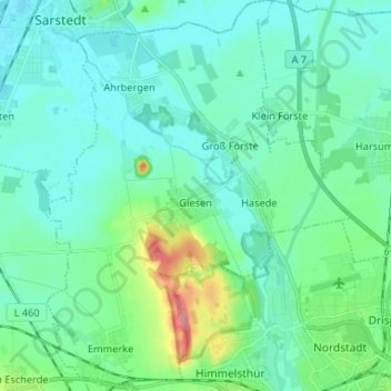
Name: Giesen topographic map, elevation, terrain.
Location: Giesen, Landkreis Hildesheim, Nedersaksen, 31180, Duitsland (52.15752 9.84842 52.23805 9.95134)
Average elevation: 82 m
Minimum elevation: 61 m
Maximum elevation: 174 m
Other topographic maps
Click on a map to view its topography, its elevation and its terrain.
Müggelsee
Duitsland > Nedersaksen > Landkreis Hildesheim > Hildesheim
Müggelsee, Drispenstedt, Hildesheim, Landkreis Hildesheim, Nedersaksen, 31135, Duitsland
Average elevation: 91 m
Hildesheim
Duitsland > Nedersaksen > Landkreis Hildesheim
Hildesheim, Landkreis Hildesheim, Nedersaksen, Duitsland, Halsberg
Average elevation: 156 m
Elze
Duitsland > Nedersaksen > Landkreis Hildesheim
Elze, Landkreis Hildesheim, Nedersaksen, 31008, Duitsland
Average elevation: 104 m