
Sensweiler topographic map
Interactive map
Click on the map to display elevation.
About this map
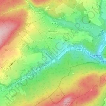
Name: Sensweiler topographic map, elevation, terrain.
Average elevation: 524 m
Minimum elevation: 409 m
Maximum elevation: 660 m
Other topographic maps
Click on a map to view its topography, its elevation and its terrain.
Baumholder
Duitsland > Rijnland-Palts > Landkreis Birkenfeld
Baumholder, Landkreis Birkenfeld, Rijnland-Palts, 55774, Duitsland
Average elevation: 451 m
Eckersweiler
Duitsland > Rijnland-Palts > Landkreis Birkenfeld
Eckersweiler, Baumholder, Landkreis Birkenfeld, Rijnland-Palts, Duitsland
Average elevation: 519 m
Allenbach
Duitsland > Rijnland-Palts > Landkreis Birkenfeld > Allenbach
Allenbach, Herrstein-Rhaunen, Landkreis Birkenfeld, Rijnland-Palts, Duitsland
Average elevation: 566 m
Hattgenstein
Duitsland > Rijnland-Palts > Landkreis Birkenfeld > Hattgenstein
Hattgenstein, Birkenfeld, Landkreis Birkenfeld, Rijnland-Palts, Duitsland
Average elevation: 552 m
Heimbach
Duitsland > Rijnland-Palts > Landkreis Birkenfeld
Heimbach, Baumholder, Landkreis Birkenfeld, Rijnland-Palts, Duitsland
Average elevation: 412 m
Huben
Duitsland > Rijnland-Palts > Landkreis Birkenfeld > Hintertiefenbach
Huben, Hintertiefenbach, Herrstein-Rhaunen, Landkreis Birkenfeld, Rijnland-Palts, 55743, Duitsland
Average elevation: 422 m