
Make a donation
Ait Ahmed topographic map
Click on the map to display elevation.
Make a donation
About this map
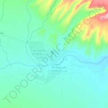
Name: Ait Ahmed topographic map, elevation, terrain.
Average elevation: 1,078 m
Minimum elevation: 1,015 m
Maximum elevation: 1,280 m
Make a donation
Other topographic maps
Click on a map to view its topography, its elevation and its terrain.
M'Hamid El Ghizlane
Morocco > Drâa-Tafilalet > Cercle de Zagora دائرة زاكورة
M'Hamid lies at an altitude of about 500 metres (1,600 ft) above sea level and about 24 kilometres (15 mi) from the Algerian border at the edge of the Sahara. M'Hamid can be reached at the end of National Route 9 from Ouarzazate (260 km) via Zagora (approx. 97 kilometres (60 mi)). Mhamid lies on the Wadi Draa,…
Average elevation: 642 m
Make a donation
M'Hamid El Ghizlane
Morocco > Drâa-Tafilalet > Cercle de Zagora دائرة زاكورة
M'Hamid lies at an altitude of about 500 metres (1,600 ft) above sea level and about 24 kilometres (15 mi) from the Algerian border at the edge of the Sahara. M'Hamid can be reached at the end of National Route 9 from Ouarzazate (260 km) via Zagora (approx. 97 kilometres (60 mi)). Mhamid lies on the Wadi Draa,…
Average elevation: 642 m
Haut Atlas Oriental National Park
This site covers 55,252 ha of the High Atlas between Midelt and Er Rachidia. The base rock consists of limestone with some igneous intrusions. The site ranges in altitude from 1,645 m in the bed of the Oued Arheddou to 3,102 m at the summit of Jbel Tanrhourt. At its western end it includes the twin lakes of…
Average elevation: 1,984 m
Make a donation
Oued Naam وادي النعام
Morocco > Drâa-Tafilalet > Cercle d'Errachidia دائرة الرشيدية
Average elevation: 1,077 m
Tinghir
Morocco > Drâa-Tafilalet > Pachalik de Tinghir باشوية تنغير
Tinghir is an oasis about 30 kilometres (19 mi) long and about 4 kilometres (2.5 mi) wide. The climate is arid subtropical: hot, dry winters about altitude (1,430 metres (4,690 ft)). There are a few rainy days per year, with the greatest precipitation in fall and winter.
Average elevation: 1,352 m
Make a donation
Imilchil
Morocco > Drâa-Tafilalet > Cercle d'Imilchil
It is located at an elevation of 2119 m in the valley of Asif Mellulen ("white river"). The area of Imilchil is home to the Ayt Hdiddu tribe, belonging to the Ait Yafelman confederation, and the inhabitants speak Central Atlas Tamazight. Tourist attractions in the area include the caves of Axyam (Akhyam), the…
Average elevation: 2,484 m
Errachidia
Morocco > Drâa-Tafilalet > Pachalik de Er Rachidia باشوية الرشيدية
Average elevation: 1,036 m
Make a donation