
Porto Covo topographic map
Interactive map
Click on the map to display elevation.
About this map
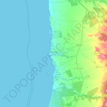
Name: Porto Covo topographic map, elevation, terrain.
Location: Porto Covo, Sines, Setúbal, Portugal (37.80495 -8.79990 37.89573 -8.71353)
Average elevation: 36 m
Minimum elevation: 0 m
Maximum elevation: 197 m
Other topographic maps
Click on a map to view its topography, its elevation and its terrain.