
Make a donation
Pittsburgh topographic map
Click on the map to display elevation.
Make a donation
Pittsburgh
The warmest month of the year in Pittsburgh is July, with a 24-hour average of 73.2 °F (22.9 °C). Conditions are often humid, and combined with highs reaching 90 °F (32 °C) on an average 9.5 days a year, a considerable heat index arises. The coolest month is January, when the 24-hour average is 28.8 °F (−1.8 °C), and lows of 0 °F (−18 °C) or below can be expected on an average 2.6 nights per year. Officially, record temperatures range from −22 °F (−30 °C), on January 19, 1994 to 103 °F (39 °C), which occurred three times, most recently on July 16, 1988; the record cold daily maximum is −3 °F (−19 °C), which occurred three times, most recently the day of the all-time record low, while, conversely, the record warm daily minimum is 82 °F (28 °C) on July 1, 1901. Due to elevation and location on the windward side of the Appalachian Mountains, 100 °F (38 °C)+ readings are very rare, and were last seen on July 15, 1995.
Make a donation
About this map
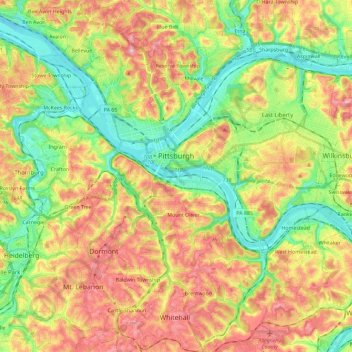
Name: Pittsburgh topographic map, elevation, terrain.
Location: Pittsburgh, Allegheny County, Pennsylvania, United States (40.36152 -80.09552 40.50120 -79.86573)
Average elevation: 303 m
Minimum elevation: 212 m
Maximum elevation: 413 m
Make a donation