
Batley topographic map
Interactive map
Click on the map to display elevation.
About this map
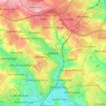
Name: Batley topographic map, elevation, terrain.
Average elevation: 111 m
Minimum elevation: 32 m
Maximum elevation: 207 m
Other topographic maps
Click on a map to view its topography, its elevation and its terrain.
Lindley
United Kingdom > England > Kirklees
Lindley, Kirklees, West Yorkshire, England, HD3 3LZ, United Kingdom
Average elevation: 184 m
Heights
United Kingdom > England > Kirklees > Linthwaite
Heights, Linthwaite, Kirklees, West Yorkshire, England, HD7 5TL, United Kingdom
Average elevation: 211 m
Shepley Lane Head
United Kingdom > England > Kirklees > Shepley
Shepley Lane Head, Kirkburton, Shepley, Kirklees, West Yorkshire, England, HD8 8BN, United Kingdom
Average elevation: 253 m
Gomersal
United Kingdom > England > Kirklees
Gomersal, Kirklees, West Yorkshire, England, BD19 4JR, United Kingdom
Average elevation: 133 m
Culvert
United Kingdom > England > Kirklees
Culvert, Kirklees, Yorkshire and the Humber, England, WF12 7QY, United Kingdom
Average elevation: 107 m
Kirklees
United Kingdom > England > Kirklees
Kirklees, West Yorkshire, Yorkshire and the Humber, England, United Kingdom
Average elevation: 220 m
Golcar
United Kingdom > England > Kirklees
Golcar, Kirklees, West Yorkshire, England, HD7 4AL, United Kingdom
Average elevation: 219 m