
Valouta topographic map
Interactive map
Click on the map to display elevation.
About this map
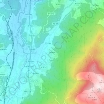
Name: Valouta topographic map, elevation, terrain.
Location: Valouta, Perdecanai, Barro, Pontevedra, Galicia, 36194, España (42.51536 -8.64640 42.55536 -8.60640)
Average elevation: 178 m
Minimum elevation: 26 m
Maximum elevation: 587 m
Other topographic maps
Click on a map to view its topography, its elevation and its terrain.
Perdecanai
España > Galicia > Pontevedra > Barro
Perdecanai, Barro, Pontevedra, Galicia, 36194, España
Average elevation: 233 m
Barro
España > Galicia > Pontevedra > Barro
Barro, Pontevedra, Galicia, España
Average elevation: 104 m