Perry topographic map
Interactive map
Click on the map to display elevation.
About this map
![Perry topographic map, elevation, terrain](/pub/maps/relation/7x1h/f87gp/thumbnail.jpg)
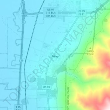
Name: Perry topographic map, elevation, terrain.
Location: Perry, Box Elder County, Utah, United States (41.43948 -112.07825 41.49162 -112.00572)
Average elevation: 1,429 m
Minimum elevation: 1,281 m
Maximum elevation: 2,261 m
Other topographic maps
Click on a map to view its topography, its elevation and its terrain.
![Plymouth topographic map, elevation, terrain](/pub/maps/relation/kzz4/s4wdn/icon.jpg)
Plymouth
United States > Utah > Box Elder County
Plymouth, Box Elder County, Utah, United States
Average elevation: 1,391 m
![Riverside topographic map, elevation, terrain](/pub/maps/relation/8frr/kfw18/icon.jpg)
Riverside
United States > Utah > Box Elder County
Riverside, Box Elder County, Utah, 84334, United States
Average elevation: 1,341 m
![South Willard topographic map, elevation, terrain](/pub/maps/relation/xb18/c51nx/icon.jpg)
South Willard
United States > Utah > Box Elder County
South Willard, Box Elder County, Utah, 84340, United States
Average elevation: 1,417 m
![Howell topographic map, elevation, terrain](/pub/maps/relation/xr18/c54nx/icon.jpg)
Howell
United States > Utah > Box Elder County
Howell, Box Elder County, Utah, 84316, United States
Average elevation: 1,460 m
![Grouse Creek topographic map, elevation, terrain](/pub/maps/node/wh4s/xbqjg3l/icon.jpg)
Grouse Creek
United States > Utah > Box Elder County
Grouse Creek, Box Elder County, Utah, 84313, United States
Average elevation: 1,653 m
![Elwood topographic map, elevation, terrain](/pub/maps/relation/sw51/t2f3q/icon.jpg)
Elwood
United States > Utah > Box Elder County
Elwood, Box Elder County, Utah, United States
Average elevation: 1,304 m
![Honeyville topographic map, elevation, terrain](/pub/maps/relation/bq3l/6s9z4/icon.jpg)
Honeyville
United States > Utah > Box Elder County
Honeyville, Box Elder County, Utah, 84314, United States
Average elevation: 1,437 m
![Brigham City topographic map, elevation, terrain](/pub/maps/relation/gj4s/lm6gt/icon.jpg)
Brigham City
United States > Utah > Box Elder County
Brigham City, Box Elder County, Utah, United States
Average elevation: 1,529 m
![Willard topographic map, elevation, terrain](/pub/maps/relation/sd51/t243q/icon.jpg)
Willard
United States > Utah > Box Elder County
Willard, Box Elder County, Utah, 84340, United States
Average elevation: 1,484 m
![Willard Bay topographic map, elevation, terrain](/pub/maps/way/2srr/3g7hs18/icon.jpg)
Willard Bay
United States > Utah > Box Elder County
Willard Bay, Box Elder County, Utah, United States
Average elevation: 1,282 m
![Bear River City topographic map, elevation, terrain](/pub/maps/relation/7xnh/5xzt6/icon.jpg)
Bear River City
United States > Utah > Box Elder County
Bear River City, Box Elder County, Utah, United States
Average elevation: 1,295 m
![Garland topographic map, elevation, terrain](/pub/maps/relation/kw14/x6bzs/icon.jpg)
Garland
United States > Utah > Box Elder County
Garland, Box Elder County, Utah, 84312, United States
Average elevation: 1,322 m
![Corinne topographic map, elevation, terrain](/pub/maps/relation/kz14/x6rzs/icon.jpg)
Corinne
United States > Utah > Box Elder County
Corinne, Box Elder County, Utah, United States
Average elevation: 1,288 m
![Brigham City topographic map, elevation, terrain](/pub/maps/node/d4gt/xbjk3kl/icon.jpg)
Brigham City
United States > Utah > Box Elder County > Brigham City > Brigham City
Brigham City, Box Elder County, Utah, 84303, United States
Average elevation: 1,489 m