
Písek topographic map
Interactive map
Click on the map to display elevation.
Písek
Písek is located about 42 kilometres (26 mi) northwest of České Budějovice and 80 km (50 mi) south of Prague. Most of the municipal territory lies in the Tábor Uplands, but the southern part lies in the České Budějovice Basin. There are several steep streets and some suburbs lie more than 70–90 metres above the town centre. The eastern part of the territory, known as the Písecké hory Nature Park, is covered by deciduous woodlands mixed with high number of various coniferous trees. The highest point of Písek and of the nature park is Velký Mehelník with an altitude of 633 metres (2,077 ft). The lowest point is located on the surface of the Otava at 350 m (1,150 ft).
About this map
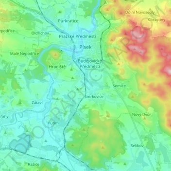
Name: Písek topographic map, elevation, terrain.
Location: Písek, okres Písek, Southwest, Czechia (49.23740 14.10005 49.33595 14.23860)
Average elevation: 421 m
Minimum elevation: 355 m
Maximum elevation: 626 m