
Gore District topographic map
Interactive map
Click on the map to display elevation.
About this map
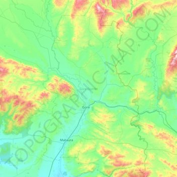
Name: Gore District topographic map, elevation, terrain.
Location: Gore District, Southland, New Zealand (-46.29885 168.70131 -45.79134 169.19829)
Average elevation: 203 m
Minimum elevation: 30 m
Maximum elevation: 827 m
Other topographic maps
Click on a map to view its topography, its elevation and its terrain.
Piano Flat
New Zealand > Southland > Southland District
Piano Flat, Glenaray Station, Southland District, Southland, New Zealand
Average elevation: 295 m
Invercargill
New Zealand > Southland > Invercargill City > Invercargill
Invercargill, Invercargill City, Southland, 9810, New Zealand
Average elevation: 16 m
Riverton
New Zealand > Southland > Southland District > Oraka Aparima Community
Riverton, Oraka Aparima Community, Southland District, Southland, 9822, New Zealand
Average elevation: 16 m
Wyndham
New Zealand > Southland > Southland District > Waihopai Toetoe Community
Wyndham, Waihopai Toetoe Community, Southland District, Southland, 9831, New Zealand
Average elevation: 32 m
Myross Bush
New Zealand > Southland > Invercargill City
Myross Bush, Invercargill City, Southland, 9872, New Zealand
Average elevation: 18 m
Pahia
New Zealand > Southland > Southland District > Tuatapere Te Waewae Community
Pahia, Tuatapere Te Waewae Community, Southland District, Southland, New Zealand
Average elevation: 15 m
Rakahouka
New Zealand > Southland > Southland District > Waihopai Toetoe Community
Rakahouka, Waihopai Toetoe Community, Southland District, Southland, New Zealand
Average elevation: 38 m
Longbush
New Zealand > Southland > Southland District > Waihopai Toetoe Community
Longbush, Waihopai Toetoe Community, Southland District, Southland, New Zealand
Average elevation: 32 m
Balfour
New Zealand > Southland > Southland District
Balfour, Southland District, Southland, New Zealand
Average elevation: 171 m
Northern Community
New Zealand > Southland > Southland District
Northern Community, Southland District, Southland, New Zealand
Average elevation: 600 m
Long Beach
New Zealand > Southland > Southland District > Waihopai Toetoe Community
Long Beach, Waihopai Toetoe Community, Southland District, Southland, New Zealand
Average elevation: 36 m
Te Ara a Kewa / Foveaux Strait
Te Ara a Kewa / Foveaux Strait, Southland, 9240, New Zealand
Average elevation: 30 m
Mamaku Point
New Zealand > Southland > Southland District > Stewart Island / Rakiura Community
Mamaku Point, Stewart Island / Rakiura Community, Southland District, Southland, 9818, New Zealand
Average elevation: 14 m
The Key
New Zealand > Southland > Southland District > Fiordland Community
The Key, Fiordland Community, Southland District, Southland, 9672, New Zealand
Average elevation: 325 m
Invercargill City
Invercargill City, Southland, New Zealand
Average elevation: 11 m
Te Anau
New Zealand > Southland > Southland District > Fiordland Community
Te Anau, Fiordland Community, Southland District, Southland, 9600, New Zealand
Average elevation: 249 m
Dipton West
New Zealand > Southland > Southland District > Oreti Community > Dipton West
Dipton West, Oreti Community, Southland District, Southland, 9791, New Zealand
Average elevation: 132 m
Oban
New Zealand > Southland > Southland District > Stewart Island/Rakiura Community > Oban
Oban, Stewart Island/Rakiura Community, Southland District, Southland, 9818, New Zealand
Average elevation: 23 m
Riversdale
New Zealand > Southland > Southland District
Riversdale, Southland District, Southland, New Zealand
Average elevation: 129 m
Opio
New Zealand > Southland > Southland District > Wallace Takitimu Community > Opio
Opio, Wallace Takitimu Community, Southland District, Southland, New Zealand
Average elevation: 175 m
Ohai
New Zealand > Southland > Southland District > Wallace Takitimu Community
Ohai, Wallace Takitimu Community, Southland District, Southland, New Zealand
Average elevation: 188 m
Winton
New Zealand > Southland > Southland District > Oreti Community
Winton, Oreti Community, Southland District, Southland, 9720, New Zealand
Average elevation: 57 m
Mataura
New Zealand > Southland > Gore District
Mataura, Gore District, Southland, 9712, New Zealand
Average elevation: 105 m
Thomsons Crossing
New Zealand > Southland > Southland District > Oreti Community > Thomsons Crossing
Thomsons Crossing, Oreti Community, Southland District, Southland, 9781, New Zealand
Average elevation: 42 m
Slope Point
New Zealand > Southland > Southland District > Waihopai Toetoe Community > Slope Point
Slope Point, Waihopai Toetoe Community, Southland District, Southland, New Zealand
Average elevation: 36 m
Little River
New Zealand > Southland > Southland District > Stewart Island/Rakiura Community
Little River, Stewart Island/Rakiura Community, Southland District, Southland, 9846, New Zealand
Average elevation: 62 m
Lumsden
New Zealand > Southland > Southland District > Northern Community
Lumsden, Northern Community, Southland District, Southland, 9730, New Zealand
Average elevation: 221 m
Fiordland Community
New Zealand > Southland > Southland District
Fiordland Community, Southland District, Southland, New Zealand
Average elevation: 525 m
Gore
New Zealand > Southland > Gore District
Gore, Gore District, Southland, 9710, New Zealand
Average elevation: 118 m
West Plains
New Zealand > Southland > Invercargill City
West Plains, Invercargill City, Southland, 9816, New Zealand
Average elevation: 7 m
Milford Sound
New Zealand > Southland > Southland District > Fiordland Community
Milford Sound, Fiordland Community, Southland District, Southland, New Zealand
Average elevation: 304 m
Mossburn
New Zealand > Southland > Southland District > Northern Community
Mossburn, Northern Community, Southland District, Southland, 9747, New Zealand
Average elevation: 299 m
Manapouri
New Zealand > Southland > Southland District > Fiordland Community
Manapouri, Fiordland Community, Southland District, Southland, 7969, New Zealand
Average elevation: 213 m
Southland District
Southland District, Southland, New Zealand
Average elevation: 317 m
Kennington
New Zealand > Southland > Invercargill City
Kennington, Invercargill City, Southland, 9872, New Zealand
Average elevation: 22 m