
Fort Wright topographic map
Interactive map
Click on the map to display elevation.
About this map
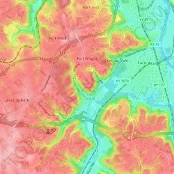
Name: Fort Wright topographic map, elevation, terrain.
Location: Fort Wright, Kenton County, Kentucky, United States (39.00704 -84.55931 39.07417 -84.51141)
Average elevation: 219 m
Minimum elevation: 139 m
Maximum elevation: 279 m
Other topographic maps
Click on a map to view its topography, its elevation and its terrain.
Pride Park
United States > Kentucky > Kenton County > Taylor Mill
Pride Park, Taylor Mill, Kenton County, Kentucky, United States
Average elevation: 237 m
Piner
United States > Kentucky > Kenton County
Piner, Kenton County, Kentucky, 41163, United States
Average elevation: 251 m
Covington
United States > Kentucky > Kenton County
Covington, Kenton County, Kentucky, United States
Average elevation: 215 m
Independence
United States > Kentucky > Kenton County
Independence, Kenton County, Kentucky, 41051, United States
Average elevation: 254 m
Erlanger
United States > Kentucky > Kenton County
Erlanger, Kenton County, Kentucky, 41018, United States
Average elevation: 258 m
Daniel Carter Beard Boyhood Home
United States > Kentucky > Kenton County > Covington
Daniel Carter Beard Boyhood Home, Licking Riverside Historic District, Covington, Kenton County, Kentucky, United States
Average elevation: 157 m
Taylor Mill
United States > Kentucky > Kenton County
Taylor Mill, Kenton County, Kentucky, 41015, United States
Average elevation: 211 m
Edgewood
United States > Kentucky > Kenton County
Edgewood, Kenton County, Kentucky, United States
Average elevation: 258 m
Austinburg
United States > Kentucky > Kenton County > Covington > Austinburg
Austinburg, Covington, Kenton County, Kentucky, 41014, United States
Average elevation: 178 m
Fort Mitchell
United States > Kentucky > Kenton County
Fort Mitchell, Kenton County, Kentucky, United States
Average elevation: 235 m
Crestview Hills
United States > Kentucky > Kenton County
Crestview Hills, Kenton County, Kentucky, United States
Average elevation: 259 m