
Oberkreith topographic map
Interactive map
Click on the map to display elevation.
About this map
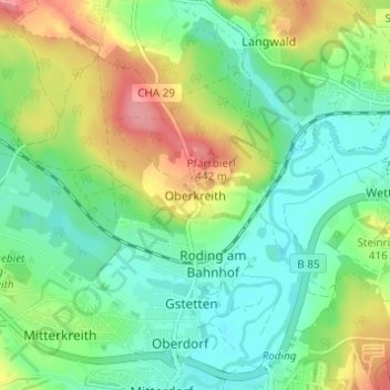
Name: Oberkreith topographic map, elevation, terrain.
Location: Oberkreith, Roding, Landkreis Cham, Bayern, 93426, Deutschland (49.20062 12.49219 49.24062 12.53219)
Average elevation: 386 m
Minimum elevation: 353 m
Maximum elevation: 448 m
Other topographic maps
Click on a map to view its topography, its elevation and its terrain.
Heidersberg
Deutschland > Bayern > Landkreis Cham > Roding
Heidersberg, Roding, Landkreis Cham, Bayern, 93483, Deutschland
Average elevation: 415 m
Wetterfeld
Deutschland > Bayern > Landkreis Cham > Roding
Wetterfeld, Roding, Landkreis Cham, Bayern, 93483, Deutschland
Average elevation: 388 m
Trasching
Deutschland > Bayern > Landkreis Cham > Roding
Trasching, Roding, Landkreis Cham, Bayern, Deutschland
Average elevation: 463 m
Strahlfeld
Deutschland > Bayern > Landkreis Cham > Roding
Strahlfeld, Roding, Landkreis Cham, Bayern, 93426, Deutschland
Average elevation: 413 m