
Sehma topographic map
Interactive map
Click on the map to display elevation.
About this map
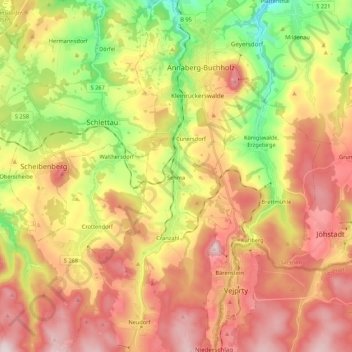
Name: Sehma topographic map, elevation, terrain.
Location: Sehma, Sehmatal, Erzgebirgskreis, Sachsen, Deutschland (50.46814 12.97000 50.60498 13.00205)
Average elevation: 681 m
Minimum elevation: 447 m
Maximum elevation: 899 m
Other topographic maps
Click on a map to view its topography, its elevation and its terrain.
Neudorf
Deutschland > Sachsen > Erzgebirgskreis > Sehmatal > Neudorf
Neudorf, Sehmatal, Erzgebirgskreis, Sachsen, 09465, Deutschland
Average elevation: 778 m
Cranzahl
Deutschland > Sachsen > Erzgebirgskreis > Sehmatal
Cranzahl, Sehmatal, Erzgebirgskreis, Sachsen, 09465, Deutschland
Average elevation: 705 m