
North Slope topographic map
Interactive map
Click on the map to display elevation.
About this map
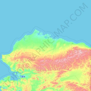
Name: North Slope topographic map, elevation, terrain.
Location: North Slope, Alaska, VS (67.99894 -166.98551 71.44106 -141.00059)
Average elevation: 214 m
Minimum elevation: -9 m
Maximum elevation: 2,518 m
Other topographic maps
Click on a map to view its topography, its elevation and its terrain.
Denali National Park and Preserve
Denali National Park and Preserve, Denali, Alaska, VS
Average elevation: 777 m
Kenai Fjords National Park
Kenai Fjords National Park, Kenai Peninsula, Alaska, VS
Average elevation: 518 m
Gates of the Arctic
Gates of the Arctic, Unorganized Borough, Alaska, VS
Average elevation: 663 m
Kosciusko Island
Kosciusko Island, Prince of Wales-Hyder, Alaska, VS
Average elevation: 81 m
Glacier Bay National Park
Glacier Bay National Park, Hoonah-Angoon, Alaska, VS
Average elevation: 556 m