
Cemoro Lawang topographic map
Interactive map
Click on the map to display elevation.
About this map
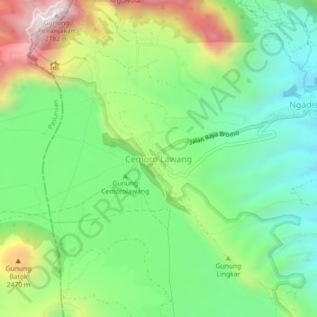
Name: Cemoro Lawang topographic map, elevation, terrain.
Average elevation: 2,171 m
Minimum elevation: 1,856 m
Maximum elevation: 2,749 m
Other topographic maps
Click on a map to view its topography, its elevation and its terrain.
Car park and lowest viewpoint
Indonesia > East Java > Probolinggo > Cemoro Lawang
Car park and lowest viewpoint, Villagers Trail to Bromo, Cemoro Lawang, Probolinggo, East Java, Indonesia
Average elevation: 2,332 m