
Douglass topographic map
Interactive map
Click on the map to display elevation.
About this map
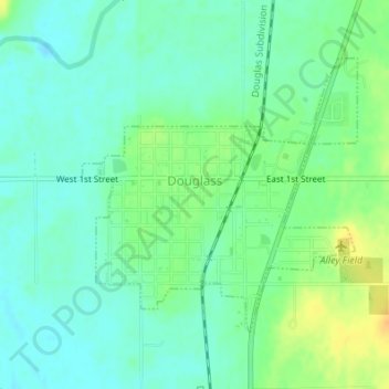
Name: Douglass topographic map, elevation, terrain.
Location: Douglass, Butler County, Kansas, United States (37.50891 -97.02267 37.52795 -96.99858)
Average elevation: 368 m
Minimum elevation: 357 m
Maximum elevation: 387 m
Other topographic maps
Click on a map to view its topography, its elevation and its terrain.
Augusta
United States > Kansas > Butler County
Augusta, Butler County, Kansas, 67010, United States
Average elevation: 387 m
Andover
United States > Kansas > Butler County
Andover, Butler County, Kansas, United States
Average elevation: 406 m
Towanda
United States > Kansas > Butler County > Towanda
Towanda, Butler County, Kansas, United States
Average elevation: 393 m
Whitewater
United States > Kansas > Butler County
Whitewater, Butler County, Kansas, United States
Average elevation: 419 m
Augusta Lake
United States > Kansas > Butler County > Augusta
Augusta Lake, Augusta, Butler County, Kansas, United States
Average elevation: 388 m
El Dorado
United States > Kansas > Butler County
El Dorado, Butler County, Kansas, 67042, United States
Average elevation: 405 m