
Attigny topographic map
Interactive map
Click on the map to display elevation.
About this map
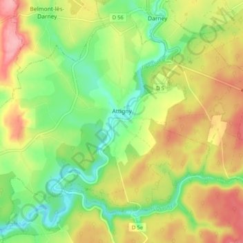
Name: Attigny topographic map, elevation, terrain.
Average elevation: 303 m
Minimum elevation: 249 m
Maximum elevation: 366 m
La commune fait partie de la Communauté de communes "du Pays de Saône et les 258 habitants du village de Attigny vivent sur une superficie totale de 16 km2 avec une densité de 16 habitants par km2 et à une moyenne d’altitude de 260 m.
Other topographic maps
Click on a map to view its topography, its elevation and its terrain.