
Germantown topographic map
Interactive map
Click on the map to display elevation.
About this map
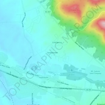
Name: Germantown topographic map, elevation, terrain.
Average elevation: 274 m
Minimum elevation: 225 m
Maximum elevation: 509 m
Other topographic maps
Click on a map to view its topography, its elevation and its terrain.
Green Village
United States > Pennsylvania > Franklin County > Greene Township
Green Village, Greene Township, Franklin County, Pennsylvania, 17254, United States
Average elevation: 207 m
Greenwood
United States > Pennsylvania > Franklin County > Greene Township
Greenwood, Greene Township, Franklin County, Pennsylvania, 17222, United States
Average elevation: 305 m
Smoketown
United States > Pennsylvania > Franklin County > Greene Township
Smoketown, Greene Township, Franklin County, Pennsylvania, 17254, United States
Average elevation: 234 m
Scotland
United States > Pennsylvania > Franklin County > Greene Township
Scotland, Greene Township, Franklin County, Pennsylvania, 17254, United States
Average elevation: 220 m
Fayetteville
United States > Pennsylvania > Franklin County > Greene Township
Fayetteville, Greene Township, Franklin County, Pennsylvania, United States
Average elevation: 248 m
Caledonia State Park
United States > Pennsylvania > Franklin County > Greene Township > Caledonia Park
Caledonia State Park, Piney Mountain Ridge Road, Caledonia Park, Greene Township, Franklin County, Pennsylvania, United States
Average elevation: 367 m