
Rubiá topographic map
Interactive map
Click on the map to display elevation.
About this map
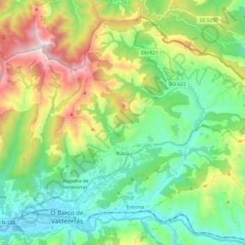
Name: Rubiá topographic map, elevation, terrain.
Location: Rubiá, Valdeorras, Ourense, Galicia, Spain (42.41010 -6.98122 42.52054 -6.80832)
Average elevation: 715 m
Minimum elevation: 307 m
Maximum elevation: 1,608 m
Other topographic maps
Click on a map to view its topography, its elevation and its terrain.
Santoalla
Spain > Galicia > Valdeorras > Petín
Santoalla, Santoalla do Monte, Petín, Valdeorras, Ourense, Galicia, 32357, Spain
Average elevation: 1,018 m