
Corbion topographic map
Interactive map
Click on the map to display elevation.
About this map
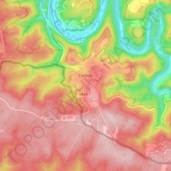
Name: Corbion topographic map, elevation, terrain.
Average elevation: 338 m
Minimum elevation: 190 m
Maximum elevation: 443 m
Other topographic maps
Click on a map to view its topography, its elevation and its terrain.
Poupehan
België > Luxemburg > Neufchâteau > Bouillon
Poupehan, Bouillon, Neufchâteau, Luxemburg, Wallonië, België
Average elevation: 270 m
Dohan
België > Luxemburg > Neufchâteau > Bouillon
Dohan, Bouillon, Neufchâteau, Luxemburg, Wallonië, België
Average elevation: 281 m