
Sedons topographic map
Interactive map
Click on the map to display elevation.
About this map
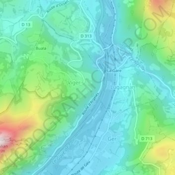
Name: Sedons topographic map, elevation, terrain.
Average elevation: 541 m
Minimum elevation: 384 m
Maximum elevation: 1,068 m
Other topographic maps
Click on a map to view its topography, its elevation and its terrain.
Viger
France > Occitania > Hautes Pyrenees > Viger
Viger, Argelès-Gazost, Hautes Pyrenees, Occitania, Metropolitan France, 65100, France
Average elevation: 543 m