
Leavesden topographic map
Interactive map
Click on the map to display elevation.
About this map
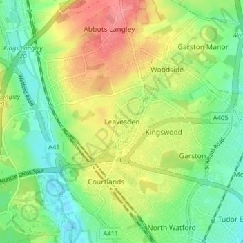
Name: Leavesden topographic map, elevation, terrain.
Average elevation: 90 m
Minimum elevation: 59 m
Maximum elevation: 132 m
Other topographic maps
Click on a map to view its topography, its elevation and its terrain.
Sarratt
United Kingdom > England > Hertfordshire > Three Rivers
Sarratt, Three Rivers, Hertfordshire, England, United Kingdom
Average elevation: 107 m
Abbots Langley
United Kingdom > England > Hertfordshire > Three Rivers
Abbots Langley, Three Rivers, Hertfordshire, England, United Kingdom
Average elevation: 102 m
Croxley Green
United Kingdom > England > Hertfordshire > Three Rivers
Croxley Green, Three Rivers, Hertfordshire, England, United Kingdom
Average elevation: 67 m
Primrosehill
United Kingdom > England > Hertfordshire > Three Rivers > Abbots Langley
Primrosehill, Abbots Langley, Three Rivers, Hertfordshire, England, WD4 8HR, United Kingdom
Average elevation: 111 m
Batchworth Heath
United Kingdom > England > Hertfordshire > Three Rivers
Batchworth Heath, Three Rivers, Hertfordshire, England, WD3 1QB, United Kingdom
Average elevation: 76 m
Heronsgate
United Kingdom > England > Hertfordshire > Three Rivers
Heronsgate, Three Rivers, Hertfordshire, England, WD3 5DE, United Kingdom
Average elevation: 92 m
The Rookery
United Kingdom > England > Hertfordshire > Three Rivers
The Rookery, Three Rivers, Hertfordshire, England, WD19 4SA, United Kingdom
Average elevation: 72 m