
Thank you for supporting this site ❤️
Make a donation
Make a donation
Manchester topographic map
Click on the map to display elevation.
Thank you for supporting this site ❤️
Make a donation
Make a donation
Manchester
According to the United States Census Bureau, the city has a total area of 34.9 square miles (90.5 km2), of which 33.1 square miles (85.7 km2) are land and 1.9 square miles (4.8 km2) are water, comprising 5.33% of the city. Manchester is drained by the Merrimack River and its tributaries the Piscataquog River and Cohas Brook. Massabesic Lake is on the eastern border. The highest point in Manchester is atop Wellington Hill, where the elevation reaches 570 feet (170 m) above sea level.
Thank you for supporting this site ❤️
Make a donation
Make a donation
About this map
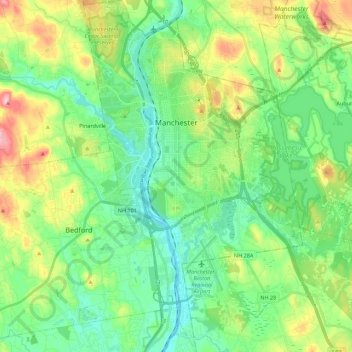
Name: Manchester topographic map, elevation, terrain.
Average elevation: 96 m
Minimum elevation: 32 m
Maximum elevation: 245 m
Thank you for supporting this site ❤️
Make a donation
Make a donation