
Thank you for supporting this site ❤️
Make a donation
Make a donation
Jashpur topographic map
Click on the map to display elevation.
Thank you for supporting this site ❤️
Make a donation
Make a donation
Jashpur
Major rivers in the Mahanadi basin are Ib and its tributaries such as Dorki, Maini, Kokiya, Utai, Khadung, Girma and Burhi. In the eastern part, rivers named Baki and Lava Nadi flow in the Brahmani basin. Lower Ganges part is mainly drained by Geor and Kanhar rivers. The drainage pattern is dendritic and is highly irregular, which is reflective of the topography. Irregular topography results in huge base flow through the streams and less recharge.
Thank you for supporting this site ❤️
Make a donation
Make a donation
About this map
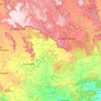
Name: Jashpur topographic map, elevation, terrain.
Location: Jashpur, Chhattisgarh, India (22.28892 83.38230 23.25172 84.39596)
Average elevation: 603 m
Minimum elevation: 212 m
Maximum elevation: 1,149 m
Thank you for supporting this site ❤️
Make a donation
Make a donation