
Grotte Santo Stefano topographic map
Interactive map
Click on the map to display elevation.
About this map
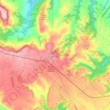
Name: Grotte Santo Stefano topographic map, elevation, terrain.
Location: Grotte Santo Stefano, Viterbo, Lazio, 01026, Italia (42.49864 12.15134 42.53864 12.19134)
Average elevation: 243 m
Minimum elevation: 134 m
Maximum elevation: 315 m
Other topographic maps
Click on a map to view its topography, its elevation and its terrain.