
Hickman County topographic map
Interactive map
Click on the map to display elevation.
About this map
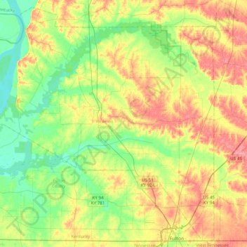
Name: Hickman County topographic map, elevation, terrain.
Location: Hickman County, Kentucky, United States (36.50261 -89.20105 36.79727 -88.81315)
Average elevation: 116 m
Minimum elevation: 83 m
Maximum elevation: 161 m
According to the U.S. Census Bureau, the county has a total area of 253 square miles (660 km2), of which 242 square miles (630 km2) is land and 11 square miles (28 km2) (4.3%) is water. The elevation in the county ranges from 276 to 510 feet (84 to 155 m) above sea level. The county's western border is formed by the Mississippi River, nearly a mile wide here, with the state of Missouri on the other side. Some portions of the county are landlocked to Missouri west of the Mississippi.
Other topographic maps
Click on a map to view its topography, its elevation and its terrain.
Bowling Green
United States > Kentucky > Warren County
Bowling Green, Warren County, Kentucky, 42101, United States
Average elevation: 169 m
Louisville
United States > Kentucky > Jefferson County
Louisville, Jefferson County, Kentucky, United States
Average elevation: 188 m
Paducah
United States > Kentucky > McCracken County
Paducah, McCracken County, Kentucky, United States
Average elevation: 108 m
Somerset
United States > Kentucky > Pulaski County
Somerset, Pulaski County, Kentucky, 42503, United States
Average elevation: 295 m
Southgate
United States > Kentucky > Campbell County
Southgate, Campbell County, Kentucky, United States
Average elevation: 212 m
Lexington
United States > Kentucky > Lexington
Lexington, Fayette County, Kentucky, 40508, United States
Average elevation: 285 m
Cumberland Falls
United States > Kentucky > McCreary County
Cumberland Falls, McCreary County, Kentucky, 42634, United States
Average elevation: 312 m
Frankfort
United States > Kentucky > Franklin County
Frankfort, Franklin County, Kentucky, United States
Average elevation: 216 m
Owensboro
United States > Kentucky > Daviess County
Owensboro, Daviess County, Kentucky, United States
Average elevation: 123 m
Hargis
United States > Kentucky > Pulaski County
Hargis, Pulaski County, Kentucky, United States
Average elevation: 283 m
Alberta
United States > Kentucky > Scott County
Alberta, Scott County, Kentucky, United States
Average elevation: 278 m
Frenchburg
United States > Kentucky > Menifee County
Frenchburg, Menifee County, Kentucky, United States
Average elevation: 330 m
Land Between the Lakes National Recreation Area
United States > Kentucky > Trigg County
Land Between the Lakes National Recreation Area, Trigg County, Kentucky, United States
Average elevation: 146 m
Rockcastle County
Rockcastle County, Kentucky, United States
Average elevation: 348 m
Fort Knox
United States > Kentucky > Fort Knox
Fort Knox, Hardin County, Kentucky, 40121, United States
Average elevation: 208 m
Elliott County
Elliott County, Kentucky, United States
Average elevation: 278 m
Nicholas County
Nicholas County, Kentucky, United States
Average elevation: 261 m
Hindman
United States > Kentucky > Knott County
Hindman, Knott County, Kentucky, United States
Average elevation: 388 m
Kentucky River
Kentucky River, Kentucky, United States
Average elevation: 260 m
Walker
United States > Kentucky > Knox County
Walker, Knox County, Kentucky, 40997, United States
Average elevation: 403 m
Little Pilot Knob
United States > Kentucky > Wayne County
Little Pilot Knob, Wayne County, Kentucky, United States
Average elevation: 374 m
Fayette County
Fayette County, Kentucky, United States
Average elevation: 282 m
Balltown
United States > Kentucky > Whitley County > Williamsburg
Balltown, Williamsburg, Whitley County, Kentucky, 40769, United States
Average elevation: 332 m
Monticello
United States > Kentucky > Wayne County
Monticello, Wayne County, Kentucky, 42633, United States
Average elevation: 304 m
Shepherdsville
United States > Kentucky > Bullitt County
Shepherdsville, Bullitt County, Kentucky, United States
Average elevation: 148 m
Danville
United States > Kentucky > Boyle County
Danville, Boyle County, Kentucky, United States
Average elevation: 290 m
Lexington
United States > Kentucky > Fayette County
Lexington, Fayette County, Kentucky, United States
Average elevation: 281 m
Newport
United States > Kentucky > Campbell County
Newport, Campbell County, Kentucky, 41071, United States
Average elevation: 173 m
Pathfork
United States > Kentucky > Harlan County
Pathfork, Harlan County, Kentucky, 40863, United States
Average elevation: 534 m
Lenarue
United States > Kentucky > Harlan County
Lenarue, Harlan County, Kentucky, 40818, United States
Average elevation: 519 m
Paint Lick
United States > Kentucky > Garrard County
Paint Lick, Garrard County, Kentucky, 40461, United States
Average elevation: 272 m
Hustonville
United States > Kentucky > Lincoln County
Hustonville, Lincoln County, Kentucky, United States
Average elevation: 316 m
Lone Star
United States > Kentucky > Hart County
Lone Star, Hart County, Kentucky, 42713, United States
Average elevation: 228 m
Sonora
United States > Kentucky > Hardin County
Sonora, Hardin County, Kentucky, United States
Average elevation: 221 m
Load
United States > Kentucky > Greenup County
Load, Greenup County, Kentucky, United States
Average elevation: 222 m
Bardo
United States > Kentucky > Harlan County
Bardo, Harlan County, Kentucky, 40830, United States
Average elevation: 634 m
Holmes Mill
United States > Kentucky > Harlan County
Holmes Mill, Harlan County, Kentucky, 40843, United States
Average elevation: 758 m
Pansy
United States > Kentucky > Harlan County
Pansy, Harlan County, Kentucky, 40830, United States
Average elevation: 602 m
Putney
United States > Kentucky > Harlan County
Putney, Harlan County, Kentucky, 40865, United States
Average elevation: 601 m
Boyd
United States > Kentucky > Harrison County
Boyd, Harrison County, Kentucky, 41003, United States
Average elevation: 214 m
Uno
United States > Kentucky > Hart County
Uno, Hart County, Kentucky, United States
Average elevation: 201 m
Elkhorn City
United States > Kentucky > Pike County
Elkhorn City, Pike County, Kentucky, United States
Average elevation: 364 m
Walnut Hill
United States > Kentucky > Fayette County > Lexington
Walnut Hill, Lexington, Fayette County, Kentucky, 40509, United States
Average elevation: 311 m
Sparrow
United States > Kentucky > Anderson County
Sparrow, Anderson County, Kentucky, United States
Average elevation: 230 m
Hartford
United States > Kentucky > Ohio County
Hartford, Ohio County, Kentucky, United States
Average elevation: 123 m
Hardyville
United States > Kentucky > Hart County
Hardyville, Hart County, Kentucky, United States
Average elevation: 212 m
Inez
United States > Kentucky > Martin County
Inez, Martin County, Kentucky, 41224, United States
Average elevation: 253 m
Alva
United States > Kentucky > Harlan County
Alva, Harlan County, Kentucky, 40863, United States
Average elevation: 652 m