
City of Coon Rapids topographic map
Interactive map
Click on the map to display elevation.
About this map
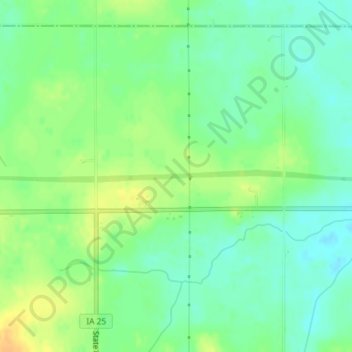
Name: City of Coon Rapids topographic map, elevation, terrain.
Location: City of Coon Rapids, Guthrie County, Iowa, United States (41.85125 -94.49276 41.85220 -94.47363)
Average elevation: 345 m
Minimum elevation: 332 m
Maximum elevation: 361 m
Other topographic maps
Click on a map to view its topography, its elevation and its terrain.
Panora
United States > Iowa > Guthrie County
Panora, Guthrie County, Iowa, United States
Average elevation: 327 m
Bagley
United States > Iowa > Guthrie County
Bagley, Guthrie County, Iowa, United States
Average elevation: 335 m
Bayard
United States > Iowa > Guthrie County
Bayard, Guthrie County, Iowa, United States
Average elevation: 343 m
Menlo
United States > Iowa > Guthrie County
Menlo, Guthrie County, Iowa, 50164, United States
Average elevation: 378 m
City of Coon Rapids
United States > Iowa > Guthrie County
City of Coon Rapids, Guthrie County, Iowa, United States
Average elevation: 337 m
Adair/Finnegan Dam
United States > Iowa > Guthrie County
Adair/Finnegan Dam, Guthrie County, Iowa, United States
Average elevation: 347 m
Jamaica
United States > Iowa > Guthrie County
Jamaica, Guthrie County, Iowa, United States
Average elevation: 317 m
Guthrie Center
United States > Iowa > Guthrie County
Guthrie Center, Guthrie County, Iowa, United States
Average elevation: 347 m
Lake Panorama
United States > Iowa > Guthrie County
Lake Panorama, Guthrie County, Iowa, United States
Average elevation: 348 m
Yale
United States > Iowa > Guthrie County
Yale, Guthrie County, Iowa, United States
Average elevation: 338 m
Casey
United States > Iowa > Guthrie County
Casey, Guthrie County, Iowa, United States
Average elevation: 389 m