
Maiduguri topographic map
Interactive map
Click on the map to display elevation.
About this map
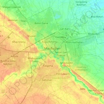
Name: Maiduguri topographic map, elevation, terrain.
Location: Maiduguri, Borno State, 600233, Nigeria (11.75350 13.07624 11.91343 13.18406)
Average elevation: 325 m
Minimum elevation: 308 m
Maximum elevation: 339 m
Other topographic maps
Click on a map to view its topography, its elevation and its terrain.
Biriri
Nigeria > Borno State > Jere > Old Maiduguri > Biriri
Biriri, Old Maiduguri, Jere, Borno State, Nigeria
Average elevation: 312 m