
La Croze topographic map
Interactive map
Click on the map to display elevation.
About this map
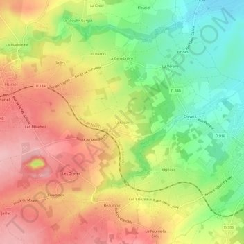
Name: La Croze topographic map, elevation, terrain.
Average elevation: 287 m
Minimum elevation: 207 m
Maximum elevation: 362 m
Other topographic maps
Click on a map to view its topography, its elevation and its terrain.
Les Mélettes
France > Auvergne-Rhône-Alpes > Allier > Huriel
Les Mélettes, Huriel, Montluçon, Allier, Auvergne-Rhône-Alpes, France métropolitaine, 03380, France
Average elevation: 322 m
Les Boueix
France > Auvergne-Rhône-Alpes > Allier > Huriel
Les Boueix, Huriel, Montluçon, Allier, Auvergne-Rhône-Alpes, France métropolitaine, 03380, France
Average elevation: 357 m
La Madeleine
France > Auvergne-Rhône-Alpes > Allier > Huriel
La Madeleine, Huriel, Montluçon, Allier, Auvergne-Rhône-Alpes, France métropolitaine, 03380, France
Average elevation: 321 m