
Thiverval topographic map
Interactive map
Click on the map to display elevation.
About this map
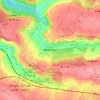
Name: Thiverval topographic map, elevation, terrain.
Average elevation: 100 m
Minimum elevation: 44 m
Maximum elevation: 131 m
Other topographic maps
Click on a map to view its topography, its elevation and its terrain.
Château de Grignon
France > Île-de-France > Yvelines > Thiverval-Grignon > Thiverval > Parc de Folleville
Château de Grignon, Allée de Thiverval, Parc de Folleville, Thiverval, Thiverval-Grignon, Rambouillet, Yvelines, Île-de-France, France métropolitaine, 78850, France
Average elevation: 108 m