
Make a donation
Houston topographic map
Click on the map to display elevation.
Make a donation
Houston
Houston is characterized by its predominantly flat topography, sitting at an average elevation of approximately 59 feet (18 meters) above sea level. The city is situated on the Gulf Coastal Plain, which is dissected by a network of bayous that contribute to the region's drainage. This terrain was once covered with forests, marshes, and swamps, remnants of which are still present in surrounding areas. The highest natural elevation in the city reaches about 150 feet (46 meters) in the northwestern region. Houston's extensive urban development has led to a significant increase in impermeable surfaces, which, combined with its flat landscape, exacerbates flooding issues, especially during heavy rains. The area's warm and humid climate further influences its topographical challenges.
Make a donation
About this map
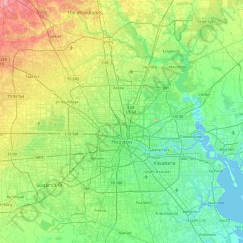
Name: Houston topographic map, elevation, terrain.
Location: Houston, Harris County, Texas, United States (29.53707 -95.90974 30.11035 -95.01205)
Average elevation: 25 m
Minimum elevation: -3 m
Maximum elevation: 98 m
Make a donation
Other topographic maps
Click on a map to view its topography, its elevation and its terrain.
Highlands
United States > Texas > Harris County
The community was named Highlands because the east bank of the San Jacinto River, where Highlands is located, has a higher elevation than the west bank of the river. By 1908, Highlands became a station on the Beaumont, Sour Lake and Western Railway. A post office opened in 1929. Highlands incorporated in 1930,…
Average elevation: 8 m
Make a donation
Make a donation
Make a donation
Make a donation
Make a donation
Make a donation
Make a donation
Make a donation
Make a donation
Make a donation
Make a donation