
Lake Michigan topographic map
Interactive map
Click on the map to display elevation.
About this map
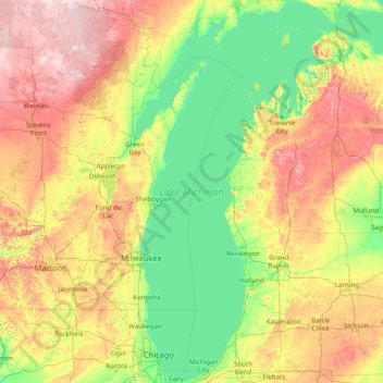
Name: Lake Michigan topographic map, elevation, terrain.
Location: Lake Michigan, Mason, Michigan, USA (41.60888 -88.04169 46.10229 -84.75208)
Average elevation: 260 m
Minimum elevation: 169 m
Maximum elevation: 582 m
Other topographic maps
Click on a map to view its topography, its elevation and its terrain.
Sterling Heights
USA > Michigan > Sterling Heights
Sterling Heights, Macomb County, Michigan, USA
Average elevation: 191 m
Pleasant Ridge
USA > Michigan > Pleasant Ridge
Pleasant Ridge, Oakland County, Michigan, USA
Average elevation: 201 m
East Lansing
USA > Michigan > East Lansing
East Lansing, Ingham County, Michigan, USA
Average elevation: 261 m
Isle Royale National Park
Isle Royale National Park, Greenstone Ridge Trail, Houghton Township, Keweenaw County, Michigan, USA
Average elevation: 189 m