
Lycoming Township topographic map
Interactive map
Click on the map to display elevation.
About this map
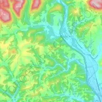
Name: Lycoming Township topographic map, elevation, terrain.
Average elevation: 284 m
Minimum elevation: 164 m
Maximum elevation: 571 m
Other topographic maps
Click on a map to view its topography, its elevation and its terrain.
Grimesville
United States > Pennsylvania > Lycoming County > Old Lycoming Township
Grimesville, Old Lycoming Township, Lycoming County, Pennsylvania, 17702, United States
Average elevation: 203 m
Williamsport
United States > Pennsylvania > Lycoming County
Williamsport, Lycoming County, Pennsylvania, United States
Average elevation: 253 m
Beaver Lake
United States > Pennsylvania > Lycoming County
Beaver Lake, Lycoming County, Pennsylvania, 17758, United States
Average elevation: 341 m