
New Albin topographic map
Interactive map
Click on the map to display elevation.
About this map
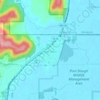
Name: New Albin topographic map, elevation, terrain.
Location: New Albin, Allamakee County, Iowa, United States (43.49265 -91.29368 43.50085 -91.28239)
Average elevation: 209 m
Minimum elevation: 187 m
Maximum elevation: 333 m
Other topographic maps
Click on a map to view its topography, its elevation and its terrain.
Waukon
United States > Iowa > Allamakee County
Waukon, Allamakee County, Iowa, 52172, United States
Average elevation: 373 m
Lansing
United States > Iowa > Allamakee County
Lansing, Allamakee County, Iowa, United States
Average elevation: 228 m
Dorchester
United States > Iowa > Allamakee County
Dorchester, Allamakee County, Iowa, 52140, United States
Average elevation: 300 m
Postville
United States > Iowa > Allamakee County
Postville, Allamakee County, Iowa, United States
Average elevation: 355 m
Elon
United States > Iowa > Allamakee County
Elon, Allamakee County, Iowa, United States
Average elevation: 335 m
Waterville
United States > Iowa > Allamakee County
Waterville, Allamakee County, Iowa, United States
Average elevation: 291 m
Harpers Ferry
United States > Iowa > Allamakee County
Harpers Ferry, Allamakee County, Iowa, United States
Average elevation: 214 m