
Magothy Forest topographic map
Interactive map
Click on the map to display elevation.
About this map
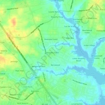
Name: Magothy Forest topographic map, elevation, terrain.
Average elevation: 13 m
Minimum elevation: -3 m
Maximum elevation: 35 m
Other topographic maps
Click on a map to view its topography, its elevation and its terrain.
Longmeadow North
United States > Maryland > Anne Arundel County > Severna Park
Longmeadow North, Severna Park, Anne Arundel County, Maryland, 21146, United States
Average elevation: 8 m
Magothy River
United States > Maryland > Anne Arundel County > Severna Park
Magothy River, Severna Park, Anne Arundel County, Maryland, United States
Average elevation: 9 m
Linstead-on-the-Severn
United States > Maryland > Anne Arundel County > Severna Park
Linstead-on-the-Severn, Severna Park, Anne Arundel County, Maryland, 21146, United States
Average elevation: 11 m
Severndale
United States > Maryland > Anne Arundel County > Severna Park > Severndale
Severndale, Severna Park, Anne Arundel County, Maryland, 22146, United States
Average elevation: 18 m
Windrush Farm
United States > Maryland > Anne Arundel County > Severna Park > Windrush Farm
Windrush Farm, Severna Park, Anne Arundel County, Maryland, 21012, United States
Average elevation: 10 m
Lower Magothy Beach
United States > Maryland > Anne Arundel County > Severna Park > Lower Magothy Beach
Lower Magothy Beach, Severna Park, Anne Arundel County, Maryland, 21122, United States
Average elevation: 9 m